
Zoning
Perinton’s Zoning Law is important for ensuring appropriately-scaled and sited development in the Town. It permits a range of uses and balances residential, commercial, and industrial development with special districts that preserve open space and agriculture. The Town also has a Mixed-Use District, which blends all uses together, and responds to recent demand for compact development and walkability.
WHAT IS ZONING?
Zoning is the regulatory tool by which municipalities control the physical development of land and the uses appropriate for each property. Typical zones include residential, commercial, industrial, and recreational. Aside from regulating land use, zoning can also be utilized to regulate buildings and streetscapes.
RESIDENTIAL DISTRICTS
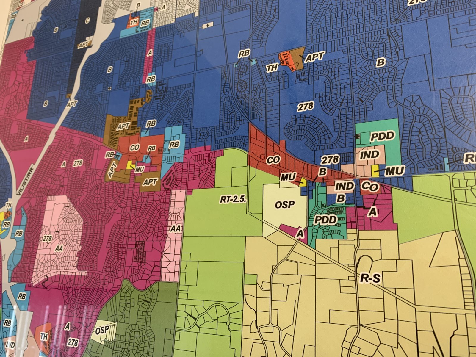
Residential districts make up the majority of the Town’s zoning. Clustering, under NYS Town Law § 278 is permitted in all. The nine residential zoning districts are:
Class AA: Single-family detached dwellings with a two-car garage, with both sewer and water provision. Townhouses, minimum 1,200 sf are permitted.
Class A: Single-family detached dwellings with a two-car garage, with at least water provision. Smaller building sizes allowed than Class AA. Townhouses, minimum 1,200 sf.
Class B: Single-family detached dwellings or two-family detached or semidetached dwellings, with at least water provision. Townhouses, minimum 800 sf.
Class C: Single-family detached dwellings or two-family detached or semidetached dwellings, with at least water provision. Smaller building sizes allowed than Class B. Townhouses, minimum 800 sf.
Apartments: One-, two-, or three-bedroom apartments in four- to twelve-dwelling apartment buildings, no more than three stories.
Townhouses: Townhouses, minimum 800 sf, at a density of no more than eight units per acre.
Residential Transition 1-2-5: Single-family detached dwellings on large (1+ acre) lots with both sewer and water provision needed to meet one-acre lot minimum.
Residential Transition RT-2.5: Single-family detached dwellings on large (2+ acre) lots with water provision needed to meet two-acre lot minimum.
Residential Sensitive District: Single-family detached dwellings with a two-car garage on at least 5-acre lots. Low density development intended to preserve environmental values.
Townhouses are permitted in the Class AA, A, B, and C districts on lots greater than 40 developable acres, but cannot exceed 10% of the developable area.
COMMERCIAL + INDUSTRIAL DISTRICTS
There are four districts within the Town that are intended for commercial, business and light industrial type uses. These include Restricted Business, Commercial, Industrial, and Mixed-Use.
The Restricted Business, Commercial, and Industrial Districts are required to have a minimum parcel size of 60,000 sf and a minimum building setback of 85 feet from the roadway. The Restricted Business and Industrial Districts allow for a range of uses related to businesses, such as professional offices, banks, hotels and mini-warehouses. The Commercial District allows uses permitted in the Restricted Business District as well as retail-type businesses, including personal services establishments, restaurants, drive-through facilities, outside dining, as well as a number of uses allowed by special permit. These districts are located in concentrated nodes and along major transportation routes within the Town, including the intersection of Route 31 and Route 250, Route 31F, and near Interstate 490 and Route 96 / Route 250.
The Town also has a Mixed-Use District, which allows for a combination of commercial, office, civic and residential uses. The Mixed-Use District was created to respect the historic development scale and patterns of Perinton’s hamlets, and to discourage strip commercial. These Districts help transition between commercial or industrial uses and residential uses, and are intended to create lively, pedestrian-friendly public realms that are accessible to residences and employment centers. The Mixed-Use District exists in pockets throughout the Town at the intersection of Route 96 and Kreag Road in Bushnell’s Basin, at the intersection of Routes 31 and 250, and at the intersections of Baird Road at Whitney and Fairport Roads.
PLANNED DEVELOPMENT DISTRICT
The Planned Development District (PDD) permits the development of land for specialized purposes where deemed suitable. Permitted uses within the PDD include residential use, accessory commercial, service and other non-residential uses, and public buildings and grounds. There are currently two tracts of land zoned PDD near the intersection of Mason Road and Route 31 and one in process on Nine Mile Point Road.
OPEN SPACE PRESERVATION
The Open Space Preservation (OSP) district is located in two areas of the Town; to the west of Route 31 and Thayer Road and on Moseley Road near the Crescent Trailhead. The purpose of this district is to preserve and enhance open space within the Town. Land in the Town may be rezoned to OSP with approval from the Town Board (if deemed appropriate) to allow adjustments to density and area requirements.
PUBLIC BUILDINGS AND GROUNDS
Public Buildings and Grounds is a special use allowing large assembly or other particular uses that primarily serve the wellness, faith, health, educational or recreational needs of the public. The use is permissible in all zoning districts with a Special Use Permit from the Town Board.
2023 Zoning Map
Click below
Contact Information
Email: Building and Codes Department

Greg Seigfred
Director of Building & Codes
(585) 223-0770